Showing 51 items matching public toilets
-
 Eltham District Historical Society Inc
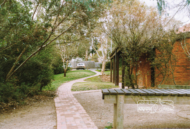
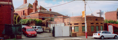
Photograph, Public toilets, Were Street, Montmorency, c.1990
... Public toilets, Were Street, Montmorency...Public Toilets... with public toilets. Before the the erection of the wind mill. Brick... melbourne Photograph Photograph Public toilets, Were Street ...Photographs of public land in Were Street, Montmorency with public toilets. Before the the erection of the wind mill. Brick paved footpath, angle parking and two public phone boxes.6 colour photographs (2 sets)montmorency, public tiolets, were street, parks, public toilets, shopping centres -
 Eltham District Historical Society Inc
Photograph, Marjorie North, Public toilets, Montmorency shops, Were Street, 1986
... Public toilets, Montmorency shops, Were Street, 1986... melbourne Photograph Public toilets, Montmorency shops, Were Street ...Negatives supplied by Marjorie North 1 July 1986 for Montmorency France albumRoll of 35mm colour negative film, 3 stripsKodak CL 200 5093montmorency, were street, shopping centre -
 Eltham District Historical Society Inc
Photograph, Public toilets, Montmorency Shopping Centre, Were Street
... Public toilets, Montmorency Shopping Centre, Were Street... melbourne Photograph Public toilets, Montmorency Shopping Centre ...Roll of 35mm colour negative film, 3 of 5 stripsKodak CP 100 5094montmorency, were street, shopping centre -
 Ballarat Heritage Services
Photograph - Colour, Public toilets hidden in earth mound, Old Sarum, England, English Heritage Site, 2016, 01 November 2016
... Public toilets hidden in earth mound, Old Sarum, England... Office goldfields Photograph - Colour Public toilets hidden ...William the Conqueror inherited Old Sarum from the last Saxon king of England. It was an ideal site for a royal castle. It was here in 1070 that William paid off his army after a long and bitter campaign in northern England. It was here in 1086 that he called together all the major landholders in England so they could swear allegiance to him. It was a crucial moment. The Domesday Book was being written, a threatened Viking invasion had only just been averted and William's eldest son was in armed rebellion. Old Sarum was an important place where this Norman king of England held power. In 1794 the Ordnance Survey set out to check the accuracy of the first mapping of Southern England, which had begun ten years earlier. From a point just below Old Sarum Lieutenant William Mudge laid out a base-line 36,574 feet (11,253 metres) long. From each end of the line the positions of distant places were plotted using a huge theodolite made in 1791 by Jesse Ramsden. The accuracy of the process, which was repeated all over England, depended on Jesse Ramsden's craftsmanship and on William Mudge's surveying skill in setting out this first base-line from Old Sarum. The nearer end of Mudge's line is marked by an inscribed stone beside the modern A345 at Old Sarum. ordnance survey, william mudge, jesse ramsden, william the conqueror, old sarum, saxon, 1086, england -
 Ballarat Heritage Services
Photograph - Colour, Entrance to Public toilets hidden in earth mound, Old Sarum, England, English Heritage Site, 2016, 01 November 2016
... Entrance to Public toilets hidden in earth mound, Old Sarum... Office goldfields Photograph - Colour Entrance to Public toilets ...William the Conqueror inherited Old Sarum from the last Saxon king of England. It was an ideal site for a royal castle. It was here in 1070 that William paid off his army after a long and bitter campaign in northern England. It was here in 1086 that he called together all the major landholders in England so they could swear allegiance to him. It was a crucial moment. The Domesday Book was being written, a threatened Viking invasion had only just been averted and William's eldest son was in armed rebellion. Old Sarum was an important place where this Norman king of England held power. In 1794 the Ordnance Survey set out to check the accuracy of the first mapping of Southern England, which had begun ten years earlier. From a point just below Old Sarum Lieutenant William Mudge laid out a base-line 36,574 feet (11,253 metres) long. From each end of the line the positions of distant places were plotted using a huge theodolite made in 1791 by Jesse Ramsden. The accuracy of the process, which was repeated all over England, depended on Jesse Ramsden's craftsmanship and on William Mudge's surveying skill in setting out this first base-line from Old Sarum. The nearer end of Mudge's line is marked by an inscribed stone beside the modern A345 at Old Sarum. ordnance survey, william mudge, jesse ramsden, william the conqueror, old sarum, saxon, 1086, england -
 Glen Eira Historical Society
Photograph - Glenhuntly Road, Glen Huntly
... Two colour photographs of a public toilet block on Glen... colour photographs of a public toilet block on Glen Huntly Road ...Two colour photographs of a public toilet block on Glen Huntly Road, north side west of the railway line. The photographs may date to the 1980s though the exact dates are unknown. Photographer unknown.glen huntly road, glenhuntly, glenhuntly road, glen huntly, toilets, public conveniences -
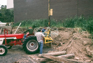 Eltham District Historical Society Inc
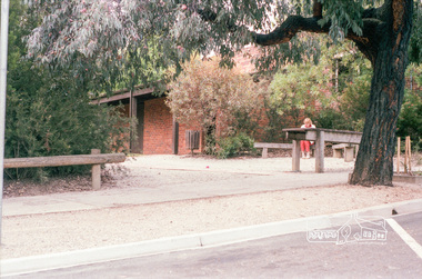
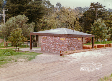
Slide - Photograph, Construction of Public Toilet, Research, c.Dec. 1980
... Construction of Public Toilet, Research...public toilets... melbourne Photograph Slide Construction of Public Toilet, Research ...Pile driving treated pine poles, Research Comfort Station, c.Dec. 198035mm colour positive transparency Mount - Kodak Kodachrome Cardinfrastructure, public toilets, research (vic.), research comfort station, construction -
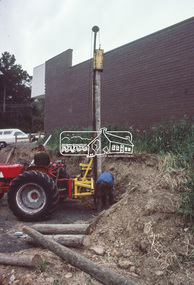 Eltham District Historical Society Inc
Slide - Photograph, Construction of Public Toilet, Research, c.Dec. 1980
... Construction of Public Toilet, Research...public toilets... melbourne Photograph Slide Construction of Public Toilet, Research ...35mm colour positive transparency Mount - Kodak Kodachrome Cardinfrastructure, public toilets, research (vic.), research comfort station, construction -
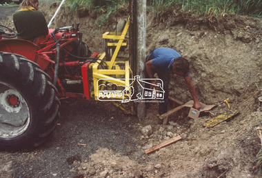 Eltham District Historical Society Inc
Slide - Photograph, Construction of Public Toilet, Research, c.Dec. 1980
... Construction of Public Toilet, Research...public toilets... melbourne Photograph Slide Construction of Public Toilet, Research ...Pile driving treated pine poles, Research Comfort Station, c.Dec. 198035mm colour positive transparency Mount - Kodak Kodachrome Cardinfrastructure, public toilets, research (vic.), research comfort station, construction -
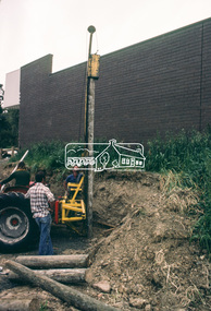 Eltham District Historical Society Inc
Slide - Photograph, Construction of Public Toilet, Research, c.Dec. 1980
... Construction of Public Toilet, Research...public toilets... melbourne Photograph Slide Construction of Public Toilet, Research ...Pile driving treated pine poles, Research Comfort Station, c.Dec. 198035mm colour positive transparency Mount - Kodak Kodachrome Cardinfrastructure, public toilets, research (vic.), research comfort station, construction, danny hick -
 Eltham District Historical Society Inc
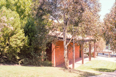
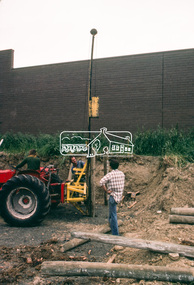
Photograph, Hurstbridge Public Conveniences, Hurstbridge-Arthurs Creek Road, Hurstbridge, c. Oct 1987, 1987
... Public Toilets... of eltham hurstbridge Hurstbridge Arthurs Creek Road Public Toilets ...Date based on other similar display panels visible in images of the Shire of Eltham display at the Eltham Community Festival, 7 November 1987.Colour photographdisplay panel, eltham festival, infrastructure, shire of eltham, hurstbridge, hurstbridge arthurs creek road, public toilets -
 Eltham District Historical Society Inc
Document - Property Binder, Eltham Town Square, Commercial Place, Eltham
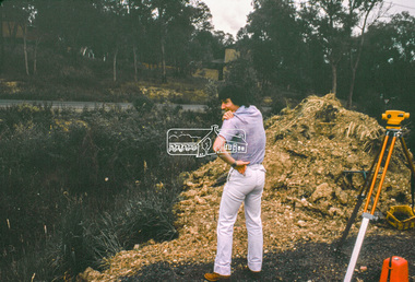
... Public Toilets... Theatre Montmorency Public Toilets Rotex Cinema Were Street ...1. Dreams to be reality, The Valley Voice, 15 August 1979, p2 - announcement of proposed town square of 1800 square metres of shop area and open courtyard to be sited in the carpark between Arthur Street and Pryor street. The plans also included tree-lined walkways from both Arthur Street and a pededstrian footbridge across Main Road leading to aregular open-air market and tavern. Shop owners facing Main Road were to be encouraged to turn their businesses towards the square. On reverse side - 'General' Marshall and his troops; Valley votes in five new faces, The Valley Voice, 15 August 1979, p1 - picture showing newly elected Cr Robert Marshall 2. Square plan on display, Diamond Valley News, Tuesday, June 23, 1981, p1 - Council's prefered proposal on display to the public. On same page a story about the son of Cr Bob Manuell being attacked on the train from the city. On reverse side - Helping people - here and abroad by Marguerite Marshall, Diamond Valley News, Tuesday, June 23, 1981, p2 - about Keith Ryall of Zig Zag Road, the Apex international councillor for Australia 3. Plan: Eltham Town Centre property Acquisition, Shire of Eltham March 1994businesses, arthur street, bible street, commercial place, dudley street, eltham, franklins supermarket, luck street, main road, map, mcewans, pryor street, safeway supermarket, apex club, bronwyn ryall, keith ryall, zig zag road, cr bob manuell, cr robert allen, det sgt noel murphy, eltham chamber of commerce, eltham police, eltham shire council, eltham town square, lorraine manuell, pauline toner mp, robert manuell, rodney roscholler, shire planner, vicrail, elections, h&j white general store, hurstbridge, leslie bowker, main street, mrs marshall, pam lawson, robert marshall, rosemary tovey, central park, comfort station, eltham little theatre, montmorency, public toilets, rotex cinema, were street -
 Glenelg Shire Council Cultural Collection
Photograph - Photograph - Colourful Mural Public Toilet Block Portland, Victoria, 1980s
... Photograph - Colourful Mural Public Toilet Block Portland... mural on public toilet block, west of the Percy St / Henty St... Mural Public Toilet Block Portland, Victoria Photograph Coloured ...Coloured polaroid photo of a colourful Australiana style mural on public toilet block, west of the Percy St / Henty St intersection in Portland. Side view of toilet block from Henty St -
Glenelg Shire Council Cultural Collection
Photograph - Photograph - Public Toilet with art, Portland, 1980s
... Photograph - Public Toilet with art, Portland...Coloured polaroid photo. Public toilet block, west.... Public toilet block, west of the Percy St / Henty St intersection ...Coloured polaroid photo. Public toilet block, west of the Percy St / Henty St intersection in Portland. Side view of toilet block from Henty St showing the 'Ladies' Toilet' sign. -
 Kew Historical Society Inc
Photograph - Former Kew Post Office : Cotham Road frontage, 1996
... front is the public toilet block, erected in the twentieth... is the public toilet block, erected in the twentieth century by the City ...A civic campaign for new public offices developed in Kew in the 1880s. After much deliberation, the location chosen was the junction of Bulleen and Cotham Roads. The buildings were designed by George Watson and John Henry Harvey, architects within the Department of Public Works (Victoria). Building was commenced in 1887, and after one year, the buildings were opened. The Post Office was transferred to the new Commonwealth Government in 1901. The Police Station and Court House, sold by the Victorian Government to the City of Boroondara in 2007, are now a community cultural centre and performing arts venue.The buildings were listed on the Victorian Heritage Register Register (HO885) in 1991. They are historically and architecturally significant to the State of Victoria because Watson and Harvey's designs exhibit diversity in integrating civil offices, they accommodate the apex of road junctions, and they demonstrate a departure from the contemporaneously favoured High Victorian Classical to the Queen Anne style in the design of civic buildings.Panoramic photograph of the entrances from Cotham Road to the Kew Post Office, Court House and Police Station. At centre front is the public toilet block, erected in the twentieth century by the City of Kew to designs by Rowland Chipperfield.kew court house, public offices -- kew (vic), kew police station, kew post office, cotham road -- kew (vic.) -
Stawell Historical Society Inc
Map - Plan, Earle and Partners, Restoration of Pleasant Creek Courthouse Stawell West 1975, 4/8/1975
... Designs for Restoration. Includes details for Public... for Restoration. Includes details for Public Toilet & Trees. Stawell ...Designs for Restoration. Includes details for Public Toilet & Trees.A1 Plan of PrecinctDrawing No. 5 4.8.1975. Pleasant Creek Court of Petty Sessions Built in 1860. Museumstawell historical -
 Glen Eira Historical Society
Photograph - Staniland Grove Elsternwick
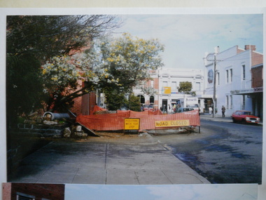
... 3 photos of Stanliand Grove Elsternwick public toilets... photos of Stanliand Grove Elsternwick public toilets under ...3 photos of Stanliand Grove Elsternwick public toilets under constructionstaniland grove, elsternwick, toilets, construction sites, glenhuntly rd -
 Kew Historical Society Inc
Photograph - Former Kew Court House : rear buildings facing Cotham Road, 1996
... public toilet -- Kew (Vic.)... is a red brick public toilet block, designed by Roland Chipperfield... is a red brick public toilet block, designed by Roland Chipperfield ...A civic campaign for new public offices developed in Kew in the 1880s. After much deliberation, the location chosen was the junction of Bulleen and Cotham Roads. The buildings were designed by George Watson and John Henry Harvey, architects within the Department of Public Works (Victoria). Building was commenced in 1887, and after one year, the buildings were opened. The Post Office was transferred to the new Commonwealth Government in 1901. The Police Station and Court House, sold by the Victorian Government to the City of Boroondara in 2007, are now a community cultural centre and performing arts venue.The buildings were listed on the Victorian Heritage Register Register (HO885) in 1991. They are historically and architecturally significant to the State of Victoria because Watson and Harvey's designs exhibit diversity in integrating civil offices, they accommodate the apex of road junctions, and they demonstrate a departure from the contemporaneously favoured High Victorian Classical to the Queen Anne style in the design of civic buildings.Original print positive photograph of two buildings on Cotham Road at the rear of the Kew Court House. On the left is a red brick public toilet block, designed by Roland Chipperfield. On the right is a red brick garage; a later addition to the Court House complex.kew court house, public offices -- kew (vic), public toilet -- kew (vic.), kew police station -
Port Melbourne Historical & Preservation Society
Photograph - Warships at Princes Pier, Port Melbourne, Douglas Smallpage, 1920s
... public toilets that later burned and was finally gutted 27 Jan... substation public toilets that later burned and was finally gutted 27 ...Late 1920's photograph taken on Princes Pier with warships probably American. Building on right was the electrical substation public toilets that later burned and was finally gutted 27 Jan 2001. The other customs shed is behind photographer Doug Smallpage. Gantries are in place.piers and wharves, doug smallpage -
 Stawell Historical Society Inc
Photograph, Old Post Office Hotel Building now occupied by a number of shops c1980's -- Coloured
... occupied by a number of shops. Public toilet on right..... Public toilet on right. Stawell Businesses ...Colour photo c1980's of Old Post Office Hotel Building now occupied by a number of shops. Public toilet on right.stawell businesses -
Whitehorse Historical Society Inc.
Article, Mitcham treated like Cinderella : Chamber, 1993
... is insufficient and the public toilets are in poor condition.... is insufficient and the public toilets are in poor condition. shopping ...Graeme Miller, president of Mitcham Chamber of Commerce says no major improvements have been made to Mitcham Shopping Centre for years.Graeme Miller, president of Mitcham Chamber of Commerce says no major improvements have been made to Mitcham Shopping Centre for years. Cr Tim Shambrook agrees and put forward a proposal to develop an action plan to improve the appearance of the Centre. The Mall is not effectively used, promotion is insufficient and the public toilets are in poor condition.Graeme Miller, president of Mitcham Chamber of Commerce says no major improvements have been made to Mitcham Shopping Centre for years.shopping centres, mitcham shopping centre, mitcham chamber of commerce, miller, graeme, shambrook, tim -
 Greensborough Historical Society
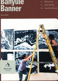
Magazine, Banyule Banner March 2024, 2024_03
... , public toilet plan, Anzac Day in Banyule and council services..., public toilet plan, Anzac Day in Banyule and council services ...The Banyule Banner is published by Banyule Council to advertise upcoming events in the City of Banyule and to report on past events. This edition contains reports on waste services, public toilet plan, Anzac Day in Banyule and council services and community events.A record of events within the City of Banyule.24 pages, colour illustrations. banyule banner, banyule council -
 Charlton Golden Grains Museum Inc
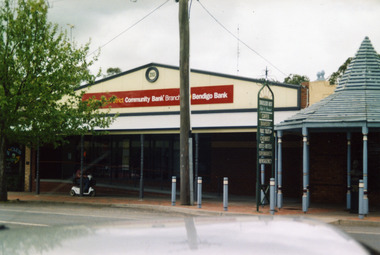
Photograph, Bendigo Bank, High St Charlton c. 2002
... for Traveller's Rest reads CAFES BAKERY PUBLIC TOILET CHEMIST HOTELS... for Traveller's Rest reads CAFES BAKERY PUBLIC TOILET CHEMIST HOTELS ...Bendigo Bank built on land formerly occupied by Clark's Butcher Shop. Branch opened in 2003.Colour photograph of Bendigo Bank building. Single storey brick building. Signage is partially obscured by tree and reads 2003 Charlton & District Community Bank Branch Bendigo Bank. Blue timber covered entrance to the Traveller's Rest complex on the RH side. Person going past on mobility scooter. Green signage for Traveller's Rest reads CAFES BAKERY PUBLIC TOILET CHEMIST HOTELS MOTELS SUPERMARKETS NEWSAGENCY. -
 Cockatoo History & Heritage Group
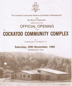
Order of Ceremony, Official Opening of the Cockatoo Community Complex, Saturday 20th November, 1982
... and public toilets. The Community Complex Building was the final..., tennis courts, netball courts and public toilets. The Community ...In 1976, the Shire of Pakenham recognising that Cockatoo was the second largest township within the shire, acknowledged requests for the provision of recreation facilities. Council purchased four hectares of land strategically located in the Town Centre and in conjunction with the local community, embarked upon a programme of staged development of the site. The first stage saw the construction of the kindergarten building which was opened in 1977, followed by the bowling green, tennis courts, netball courts and public toilets. The Community Complex Building was the final development of the site.The Cockatoo Community Complex building, was the final stage of the development and was opened on the 20th November 1982. It was a replacement for the old Cockatoo Hall, which had not been renovated since 1936. The old Cockatoo Hall was lost in the Ash Wednesday fires on the 16th February 1983. The community complex played an integral part in the recovery stages after Ash Wednesday.Four page document, including Acknowledgements, Order of Ceremony, Menu and Site Plan of the Cockatoo community ComplexTwo punctured holes for folder storagecockatoo community complex, cockatoo hall, hall opening, cockatoo -
 City of Ballarat Libraries
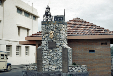
35mm Slide, Gold discovery centenary monument, Albert Street Ballarat, circa 1950s
... , with the original public toilets behind. The monument features a replica..., Ballarat facing Sturt St, with the original public toilets behind ...The Gold Discovery centenary (1851-1951) monument in its original position in Albert St, Ballarat facing Sturt St, with the original public toilets behind. The monument features a replica of the Welcome Nugget, found in 1858 and the world's largest at that time. The monument also lists the weight of gold removed from the large "deep lead" mines, with a model of surface buildings of a mine sitting on top. Mrs Bon Strange and her husband Bert were well known Ballarat residents. When Mrs Strange died some years ago, her extensive slide collection was sorted through and those relevant to Ballarat were gifted to the Ballarat Library. ballarat, vintage bus, gold mining, welcome nugget -
 Hume City Civic Collection
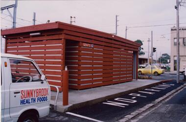
Photograph, Late 1980's
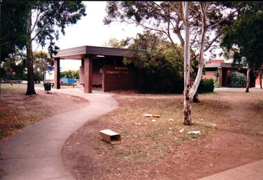
... public toilet blocks... occurred on public buildings. The toilet block was demolished.... vandalism public toilet blocks evans street sunbury comfort station ...The series of seven photographs highlight examples of vandalism within the town centre precinct. Most of the vandalism occurred on public buildings. The toilet block was demolished in the late 1990's to make way for further expansion of the retail shopping centre in Sunbury.A coloured photograph of the Sunbury Comfort Station which was erected on a section of public land in Evans Street between the post office and Sunbury Shopping Square. The brown brick building has an open porch on one side and a curved concrete path leads from the street to the building. A smaller block is in the background and a grassed ared with trees is in the foreground with rubbish thrown across the grass.vandalism, public toilet blocks, evans street, sunbury comfort station, shire of bulla, george evans collection -
 City of Moorabbin Historical Society (Operating the Box Cottage Museum)
Newsletter, City of Moorabbin Historical Society Jun 2010 pdf, June 2010
... to Glen Eira City Council for a Public Toilet at Box Cottage... for a Public Toilet at Box Cottage for visitors and volunteers ...The City of Moorabbin Historical Society was formed c 1960 by a group of Moorabbin residents who were concerned that the history of the area should be preserved. A good response to a call for items related to the historical area of Moorabbin Shire brought donations of a wide variety of artefacts which are now preserved by the current members of CMHS at Box Cottage Museum . Helen Stanley, Secretary of CMHS, began producing a Newsletter for members in April 2007 to provide current information and well researched items of historical interest. Helen Stanley has produced a bi-monthly Newsletter, 2007 - 2013, for the members of the City of Moorabbin Historical Society that contains well researched interesting historical items, notification of upcoming events, current advice from Royal Australian Historical Society , Museums Australia Victoria and activities of Local Historical Societies. The Newsletter is an important record of the activities of the CMHS. Photocopied Plan of ‘Two Acre Village c1853’ and notes about the Colonial City Morgue Melbourne c1888 7 x A4 paper printed on 1 side Issue 17 of the bi-monthly, City of Moorabbin Historical Society Newsletter produced by Society member and Secretary, Mrs Helen Stanley in June 2010. Notice of meeting June 17th and recent death of Mrs May Curtis,CMHS member. June 5th , Robina Naughton, CMHS, represented Box Cottage at the 'Fun4over50s' expo at Moorabbin Town Hall. Mr Laurie Lewis donated the 'original water pump' from the first Box Cottage and has provided a list of the commercial properties around Box Cottage c 1900, as he remembers. An application to Glen Eira City Council for a Public Toilet at Box Cottage for visitors and volunteers. A volunteer has joined CMHS following our enrolment with 'Volunteering Glen Eira'. State Library of Victoria has approved CMHS for the 'Vicnet' program where Box Cottage Museum can be promoted. Helen provides a précis, of 4 A4 pages, describing ‘The City Morgue in Colonial Melbourne’ printed in Provenance Journal No3 November 2004.CITY of MOORABBIN HISTORICAL SOCIETY / JUNE 2010 NEWSLETTERcity of moorabbin historical society, stanley helen, curtis may, graham street mckinnon, curtis geoff, moorabbin town hall, lewis laurie, lewis grace, lewis timber pty. ltd., melbourne, moorabbin, brighton, cheltenham, ormond, bentleigh, market gardeners, pioneers, early settlers, moorabbin shire, box cottage museum, water pump, elster creek, volunteering glen eira, state library of victoria, vicnet, dendy henry, dendy’s special survey 1841, mclean n, box henry, joyce park ormond, city of moorabbin, box william, jasper road east brighton, melbourne city morgue, cooke simon, brown mwy andrew -
 Ringwood and District Historical Society
Photographs, Agfa, Heathmont shops and locations in Dec 1999 (25 Photos), 29-Dec-99
... ); Heathmont public toilets (3226_013.jpg); Heathmont railway crossing... shops, buildings, parks, train tracks, scout hall, toilet block ...Photographs (25) B&W of Heathmont shops, buildings, parks, train tracks, scout hall, toilet block.Canterbury Road, Heathmont, looking south-west (3226_001.jpg); Southern part of Heathmont shopping centre, looking west (3226_002.jpg); Canterbury Road, Heathmont, looking north (3226_003.jpg); McLean's Real Estate, Heathmont (3226_004.jpg); Northern part of Heathmont shopping centre (3226_005.jpg); Heathmont shops (3226_006.jpg); Heathmont shops (3226_007.jpg); Heathmont dry cleaners (3226_008.jpg); Heathmont newsagency (3226_009.jpg); Heathmont Mother's General Store (3226_010.jpg); The Boulevard, Heathmont (3226_011.jpg); Heathmont train (3226_012.jpg); Heathmont public toilets (3226_013.jpg); Heathmont railway crossing, Allens Road (3226_014.jpg); Heathmont bicycle path, near Allens Road (3226_015.jpg); Cnr Allens Road and The Boulevard, Heathmont (3226_016.jpg); Heathmont bicycle path, near Allens Road (3226_017.jpg); Oval No. 1, HE Parker Reserve, Heathmont (3226_018.jpg); Cnr Allens Road and The Boulevard, Heathmont (3226_019.jpg); 2nd Ringwood Scout Group, HE Parker Reserve (3226_020.jpg); Railway line looking towards Heathmont Station (3226_021.jpg); HE Parker Reserve sign (3226_022.jpg); Heathmont supermarket (3226_023.jpg); Heathmont greengrocers (3226_024.jpg); Heathmont railway crossing, near Allens Road (3226_025.jpg)